
 Worldmark Encyclopedia of Cultures and Daily Life
by
Worldmark Encyclopedia of Cultures and Daily Life
by
 A Dictionary of Geography
by
A Dictionary of Geography
by
 American Trivia
by
American Trivia
by

Geography & The World
Physical Geography specifically deals with the physical environment which includes plants and animals, landforms, water bodies, weather conditions, etc.
Cultural Geography studies the different regions and cultures that are found in the world.
A landform is a feature on the Earth's surface that is part of the terrain. Mountains, hills, plateaus, and plains are the four major types of landforms. Minor landforms include buttes, canyons, valleys, and basins.
A habitat is the type of natural environment in which a particular species of organism lives. The main types are Polar, Tundra, Evergreen Forests, Seasonal Forests, Grasslands, Deserts, Rainforests, and Oceans or Aquatic.
There are six main components of weather. They are temperature, atmospheric pressure, wind, humidity, precipitation, and cloudiness. The term “weather” refers to the temporary conditions of the atmosphere, the layer of air that surrounds the Earth.
The average weather in a specific region, as well as its variations and extremes over many years, is called Climate.
A region is an area that has a number of common elements.
Natural Resources are raw materials that occur naturally in the environment such as land, water, air, copper, coal, petroleum, energy, plants, and animals.
Renewable resources are resources that the environment replaces quickly but nonrenewable resources take millions of years to form.
An ecosystem is the interaction between a community of organisms and the natural resources of the environment. Examples include rain forests, cities, coastal regions, grasslands, and deserts.
A cultural region or cultural sphere refers to the aspects of culture associated with an ethnolinguistic group and the territory it inhabits. Ethnolinguistics refers to the relationship between language and culture and how different ethnic groups perceive the world.
Demography is the statistical study of the size, growth, movement, and distribution of people.
Migration is the movement of people from one place to another. Refugee is a person who flees to a foreign country to escape danger. The act of migration causes cultural diffusion or the spread of cultural traits to other parts of the world.
Culture includes a society's beliefs, values, language arts, customs, behaviors, family relationships, and economic systems. A cultural trait or an aspect of culture form what is known as cultural patterns. Traits and patterns of culture are passed down from generation to generation.
Population density is the average number of people in a square mile.

A continent is one of Earth’s seven main divisions of land. The continents are, from largest to smallest: Asia, Africa, North America, South America, Antarctica, Europe, and Australia.
There are four named ocean basins: the Atlantic, Pacific, Indian, and Arctic. However, most countries - including the United States - now recognize the Southern (Antarctic) as the fifth ocean basin.
Geography has a tremendous impact on people and the world. In ancient times, people learned to adapt to the environments around them. For instance, in the Southwest desert areas, the Early Americans learned to grow crops that needed little rain to produce and built irrigation systems. When conditions got unsuitable for survival they would move to other locations. Early Settlers relied on Geography to determine where they would need to build their colonies. As populations grew, farmland became very scarce which made people move westward causing the United States to be expanded. People also effect the environment by cutting down trees, plowing grasslands to plant crops, cutting down trees to build houses and other buildings. In the 1860's, railroads began to be built across America changing the physical geography of the country. As technology increases so does the effect on the environment such as pollution, loss of plant and animal life, flooding, and changes in climate.
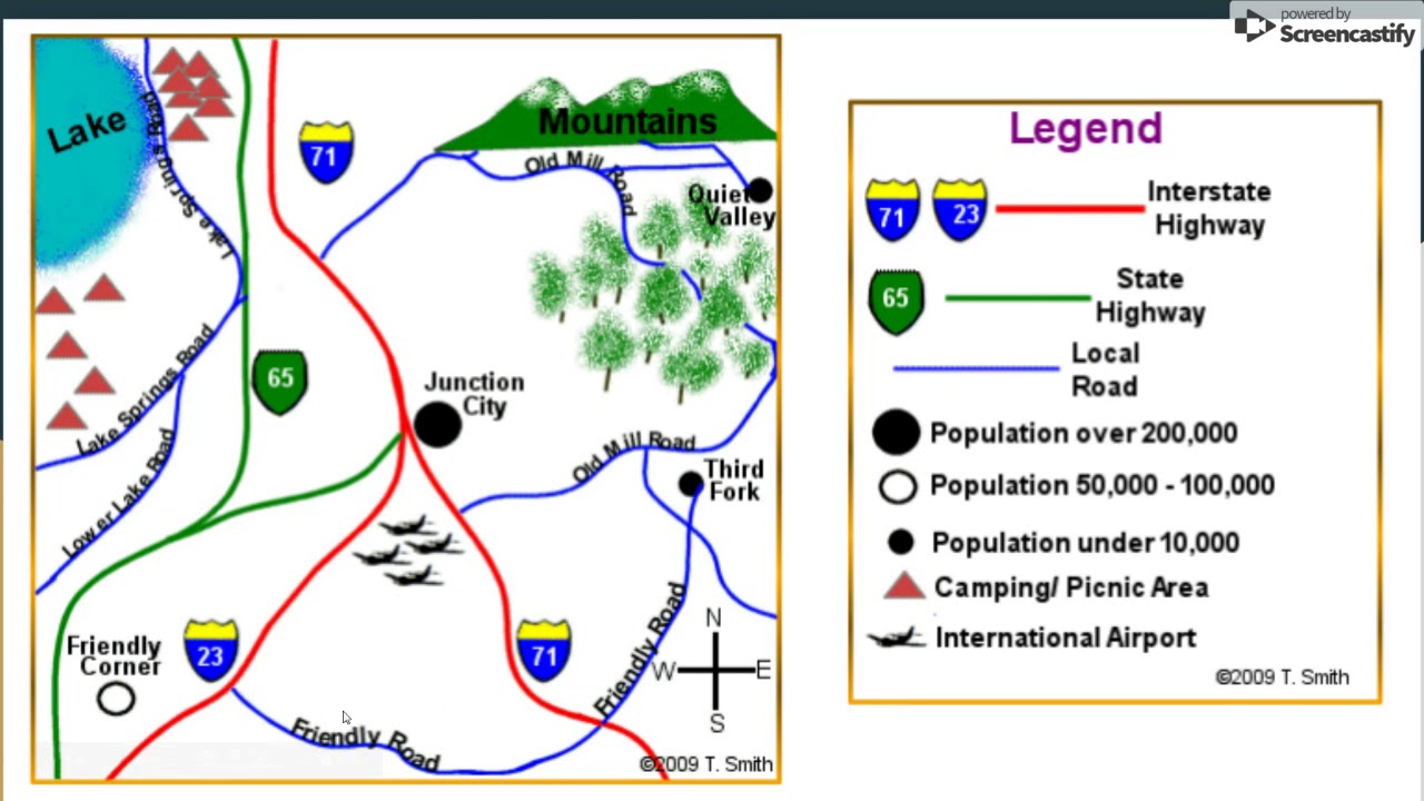
Map Key or legend: uses symbols and colors or shading to represent features of the real world. Symbols show cities, rivers, highways, boundaries, capitals, etc. Colors or shading may show climate regions, altitude, or rainfall.
When reading a map key look at what each symbol or shaded area represents then look for them on the map.
Information on a map, chart, or graph is called data
Worksheets on various topics such as women in the workforce, immigration patterns, changes in family structure, and the link between education and income.
Guides to different countries and regions on cultural customs and beliefs, arts, clothing, and more
All about geography from the National Geographic Research Library
Geography: The Science of Our World
Information on Geography and People
PhysicalGeography.net contains six main components: Fundamentals (of Physical Geography) Online eBook, Understanding (Physical Geography) Online eBook, Learning Visualizations, Glossary of Terms, Internet Weblinks, and Search Site.
GED review with videos
National Geographic Video Playlist
Video lessons on landforms, climate, and more
Lesson on early civilizations
Various topics and lessons in world History
Lesson on cultures and how they evolve
Learn about countries and their cultures

